This website is no longer updated and has been replaced with a static copy. The Spatial History Project was active at Stanford University from 2007-2022, engaging in dozens of collaborative projects led by faculty, staff, graduate students, post-docs, visiting scholars and others at Stanford and beyond. More than 150 undergraduate students from more than a dozen disciplines contributed to these projects. In addition to a robust intellectual exchange built through these partnerships, research outputs included major monographs, edited volumes, journal articles, museum exhibitions, digital articles, robust websites, and dozens of lightweight interactive visualizations, mostly developed with Adobe Flash (now defunct). While most of those publications live on in other forms, the content exclusive to this website is preserved in good faith through this static version of the site. Flash-based content is partially available in emulated form using the Ruffle emulator.
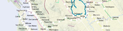
Extent of Digitized Rail
WARNING: This image has been removed.
Authors: Chester Harvey, Evgenia Shnayder, John Watson, Killeen Hanson, Erik Steiner, and Richard White
This map shows the extent of railroad network that has been traced from the historic USGS quads (pre-1915) for the Shaping the West project. The color coding identifies the different railroad branches and who owned them.This map was last updated on November 15, 2010.
RELATED VISUALIZATIONS:

Quad Index

Seeing Space in Terms of Track Length and Cost of Shipping
California Railroad Commission,
Station Construction Data, 1850-1900
Station Construction Data, 1850-1900
The Expansion of the Western Railroad
Railroad Repeats: The Alfred A. Hart Photo Project
The Central Pacific and Transcontinental Eleven Step:
How to Run a Transcontinental Railroad
How to Run a Transcontinental Railroad
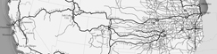
Examples of Digitizing Rail from Historic USGS Quads
RELATED PUBLICATIONS:

A Data Model for Spatial History