This website is no longer updated and has been replaced with a static copy. The Spatial History Project was active at Stanford University from 2007-2022, engaging in dozens of collaborative projects led by faculty, staff, graduate students, post-docs, visiting scholars and others at Stanford and beyond. More than 150 undergraduate students from more than a dozen disciplines contributed to these projects. In addition to a robust intellectual exchange built through these partnerships, research outputs included major monographs, edited volumes, journal articles, museum exhibitions, digital articles, robust websites, and dozens of lightweight interactive visualizations, mostly developed with Adobe Flash (now defunct). While most of those publications live on in other forms, the content exclusive to this website is preserved in good faith through this static version of the site. Flash-based content is partially available in emulated form using the Ruffle emulator.
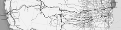
Distribution of Union Pacific Stockholders by City (1869)

Authors: Evgenia Shnayder, Toral Patel, Killeen Hanson, and Richard White
On May 10, 1869, at Promontory Summit, Utah, Americans finished the first transcontinental railroad by joining the Union Pacific (built west from Omaha) and the Central Pacific (built east from Sacramento).
The distribution of stockholders for the Union Pacific is both revealing and deceptive. This map shows a concentration of stockholders in New York and in New England, particularly in the vicinity of Boston. This reveals the way ownership of the Union Pacific concentrated in a small section of the country. However, the map is deceptive because it tempts us to conclude that the it depicts the investment of capital in the road. In fact, not all of these stockholders had bought their stock. Many of the largest stockholders had invested little or nothing in the Union Pacific; they had bought stock in the Credit Mobilier, the insider construction company that had reaped large profits from building the road and then ended up controlling the stock in the railroad. The Credit Mobilier had then distributed this stock to its investors.
The map then is not so much a map of capital invested as a map of how the West got a federally financed railroad and the East got insider networks which controlled it.
RELATED VISUALIZATIONS:
The Rise in the American Railway Union, 1893-1894
Population Density in the United States from 1790 to 2000
Union Pacific Shipping from Nebraska: Forwarded/Received
Exports from Colorado by Station in 1885
Union Pacific Shipping from Nebraska: East/West
Western Railroads and Eastern Capital: Regional Networks on Railroad Boards of Directors, 1872-1894
Tracing Railroad Directors, 1872-1894
The Expansion of the Western Railroad
Patterns of Change in Railroad Company Board Members, 1872-1894
Cattle Production in the American West, 1867-1935
Railroad Repeats: The Alfred A. Hart Photo Project
Per Capita Income in the United States: 1880-1910